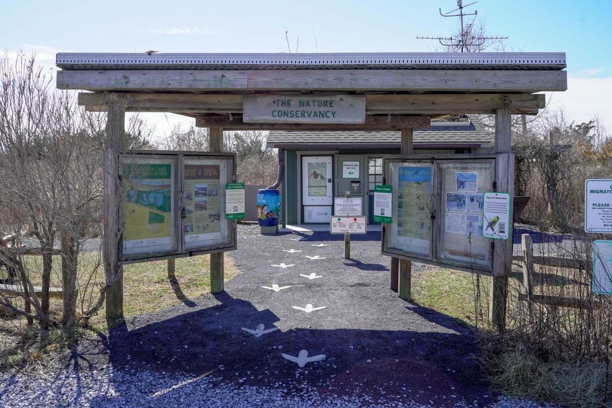
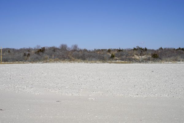
The entrance to South Cape May Meadows in Lower Township, NJ. Friday, March 7, 2025. (Gavin Schweiger)
Editor’s note: South Cape May is featured in a PBS documentary”Paradox: Rising Water and Mounting Costs,” broadcast by our news partner, NJ Spotlight News.
Don McKrell puts his binoculars to his eyes and watches a couple of swans swimming in a lake.
“I’m glad they kept this place,” he said. “It doesn’t look like a lot. At least they kept this open.”
He’s in Lower Township, in Cape May County, but he’s not from the area. He’s from Navarre, Florida, near Pensacola, and more than 1,000 miles from home.
McKrell had been travelling up the East Coast to birdwatch. He found South Cape May Meadows on the app, eBird, as a “pretty” place to find birds.
South Cape May Meadows wasn’t always open and preserved like it is now, however. The marshlands on the southernmost tip of Cape May County were home to an entire town that no longer exists: South Cape May.
In the 1880s, development started on that land, and the borough of South Cape May split from Lower Township in 1894 and became its own independent town.
Not too long after, it would become a hub of disaster.
The Jersey Shore town that vanished into the sea
Robert Kenselaar, a retired New York Public Library librarian, co-wrote the book, “Remembering South Cape May: The Jersey Shore Town that Vanished into the Sea,” with his father in-law, Joseph G. Burcher.
Burcher’s father owned a summer home in South Cape May, which was built by his grandfather in the same year he was born, 1923.
“He [Burcher] had a lot of stories about South Cape May,” Kenselaar said.
In 2006, Burcher read an article from Cape May Magazine. Having found “some errors” from their experiences in South Cape May, he and Kenselaar decided to write their own history of the town.
Kenselaar did this by interviewing Burcher and digging through the Cape May County Historical Society and library.
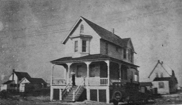
Thirteen houses were built on the South Cape May shore in 1888, and before it was even incorporated into a town, its first storm hit in 1891.
Storms would continue to hit, and through most of the Cape May shoreline, land and property management were hot-button issues.
There were different ways of dealing with the fallouts of Atlantic hurricanes and storms. At the turn of the 20th century, Cape May City and Cape May Point both constructed jetties, or structures that protrude from the land into the water.
The jetties served to protect the shoreline against threatening storms. Notably, South Cape May didn’t build any.
That’s not for lack of trying, however. There were pleas for federal funding to protect the land. Instead, the first in a series of three devastating storms ravaged the borough in 1936.
The 1936 Nor’easter destroyed multiple houses on the beachfront, including Mayor Harvey Mentzer’s house. Mentzer was at the forefront pushing for shoreline protection measures.
The Great Atlantic Hurricane in 1944, dealt the fatal blow, putting most of the town underwater.
After that storm, what was dry in South Cape May borough integrated with Lower Township in 1945. Anything left standing from the original town was washed away in a storm in 1950.
Not all of the houses were destroyed, however.
“Going way, way back in 1891, ‘92, ‘97 and…1903 there were severe storms,” Kenselaar said. “And that started the movement by homeowners to have their homes physically moved from South Cape May into the western most Section of Cape May city. And so there are 13 houses that were originally in South Cape May that are today still standing.”
Sixteen houses were originally moved. Of those, 13 houses are currently occupied, according to Kenselaar.
One of the surviving houses belongs to Lynn Dudinsky, 68, a retired business owner who lives with his wife, Linda Gast, 72.
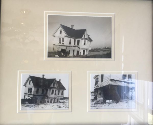
The house was built in South Cape May in the 1890s, around the time the borough was established. One of the many storms that hit the town destroyed the first floor.
“They salvaged the second and the third floor of this house, put it on a skid and drug it about 300-400 yards inland to what, at that time, was a racetrack where the house now sits,” Dudinsky said.
The home was a “summer cottage for two elderly ladies from Philadelphia,” according to Dudinsky.
Dudinsky and Gast bought the house in September 2013 at a value of $345,000. It was painted pink and blue, and no one expected them to buy it.
One factor for them buying the house, however, was the fact that South Cape May Meadows is in front of it.
“But my wife saw the potential [of the house], and I saw the value, saying, you know, nobody’s going to build in front of us,” Dudinsky said. “Within the first year, I said, let’s think about lifting this bad boy.”
They then undertook the massive project of lifting the house and building a first floor for it, among other projects.
The renovation projects and the location of the house now mean its estimated value is $1.8 million.
South Cape May Meadows
After the destruction of South Cape May until 1981, the remaining marshland was used as a cattle grazing field. There were also faint plans of creating a campground on the land.
That is, until the Nature Conservancy purchased the 200-acre plot of land in 1981. This also essentially squandered any renewed ideas of developing in former South Cape May.
It was a move made to protect an important ecosystem as well.
“Its [South Cape May Meadows’] location is so unbelievable in its importance in the migration of the birds going north and south,” said Damon Noe, critical land manager for New Jersey at the Nature Conservancy.
Many migratory birds flying on the Atlantic Flyway along the eastern United States from the North and South will find their way to Cape May as a rest point.
Noe explained the migration patterns as an hourglass, which converges in New Jersey.
“It pinches right in the hourglass at that preserve and Cape May Point, that area,” Noe said.
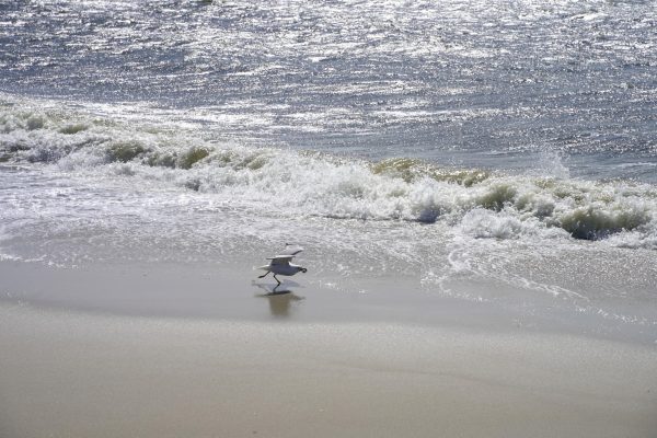
South Cape May, in that sense, is a rest stop for many bird species, including making their long and exhausting journeys from Canada, Central, and South America.
Part of accommodating the migratory birds is raising and lowering the water level using “weirs,” which are mini-dams meant to control water flow.
According to Noe, controlling water is useful because of the different types of birds that will visit or nest in the preserve over different seasons. In the spring and summer, bird species that use mud will inhabit the area, so the Nature Conservancy will lower the water flow to create mud flats.
In the fall and winter, more waterfowl like ducks will reside in the area, so the water level is raised to accommodate them.
Keeping the preserve healthy for the many species that frequent it is not an easy task, however.
While the South Cape May borough was unable to protect itself from flooding, South Cape May Meadows eventually needed to come to terms with the ocean’s power once again.
More flooding
After the Halloween Nor’Easter of 1991, which ravaged the East Coast and caused the ocean to flood into the freshwater at the preserve, the Nature Conservancy and Army Corps of Engineers erected an 18-foot-high and 1-mile-long sand dune to protect from further flooding.
The dune is also vegetated, meaning plants’ root systems strengthen it even more.
While the freshwater preserve is more protected from flooding, birds’ nesting areas on the saltwater side of the dune are not nearly as safe from rising waters.
Major storms aren’t the only problem now. Due to the changing climate, Noe said that it’s “just high tides now.”
“All these full moons, they definitely flood on beach,” Noe said. “Regular tides are coming up close, sometimes flooding over. They never did that before, and that’s a problem, especially during breeding season.”
There are other challenges that face species at the preserve, like predators and unruly after-hours visitors. However, the preserve took measures, such as building fences to keep predators away, to mitigate those issues.
In some respects, South Cape May Meadows is doing very well.
The Army Corps of Engineers worked with the preserve to create “islands” on the beach for nesting birds, such as piping plovers. These football-field sized areas are raised a few feet so the flooding is less problematic for nest-building and eggs.
The importance of South Cape May Meadows isn’t lost on Noe. While preserving nature for different bird, fish and reptile species is of great importance, there’s also the human element.
“As a genus, we spent about 3 million years in the outdoors,” Noe said. “And this thing recently, where we’re inside all the time, we have not adapted to that.”
The former South Cape May was a development project that couldn’t fight back against powerful natural factors. Built on marshland by an ocean ready to strike with the help of storms, the town could probably have never succeeded.
Perhaps jetties and other measures would have helped, but the message seems clear. It’s difficult to fight against nature instead of living with it.
The South Cape May Meadows preserve is not only a sanctuary for migratory birds and other wildlife, but for people to live alongside the natural world.